Fájl:Satellite image of Japan in May 2003.jpg
 Az előnézet mérete: További felbontások: | | | | | .
Eredeti fájl (5 800 × 7 200 képpont, fájlméret: 3,69 MB, MIME-típus: image/jpeg)
|
Ez a fájl a Wikimedia Commonsból származik. Az alább látható leírás az ottani dokumentációjának másolata. A Commons projekt szabad licencű kép- és multimédiatár. Segíts te is az építésében! |
Összefoglaló
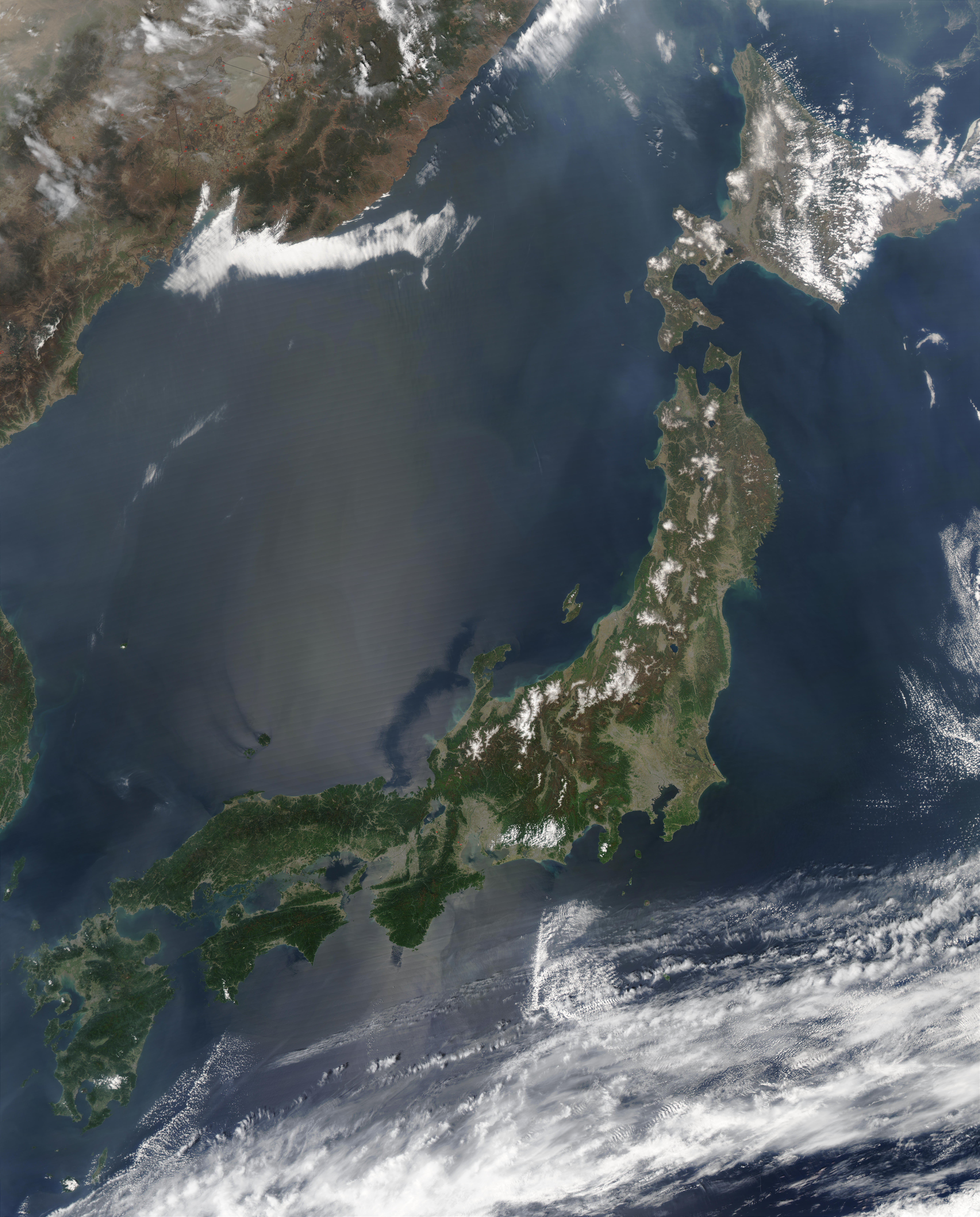
| LeírásSatellite image of Japan in May 2003.jpg | English: Satellite image of Japan in May 2003. The islands of Japan are shown clearly off the coast of North and South Korea, China, and Russia in this true-color image. Running down through the islands are a string of mountains that make up part of the Pacific “Ring of Fire.†The Ring of Fire is a zone of frequent earthquakes and volcanic eruptions that stretches in a series of arcs from New Zealand, through Indonesia, up through the Philippines, Japan, the Kuril Islands and Kamchatka Peninsula (Russia), across the Pacific Ocean via the Aleutian Islands, and down the coast of the Americas. Seventy-five percent of the world’s volcanoes are in this ring, making it the most volcanically-active region on the planet. Also shown in this image are a number of fires, which are marked with red dots. A few fires were detected in Japan, China, and North Korea, but the majority were detected in Russia’s Primorskiy-Kray region. This true-color Aqua MODIS image was acquired on May 1, 2003. 日本語: 日本の衛星画像(2003年5月) |
| Dátum | 2003. május 1. |
| Forrás | Cropped from http://visibleearth.nasa.gov/view_rec.php?id=5319 |
| Szerző | Jeff Schmaltz, MODIS Rapid Response Team, NASA/GSFC |
| Más változatok |
|
Licenc
| Ezt a fájlt a NASA készítette, ezért az Egyesült Államokban közkincsnek számít. A NASA szerzői jogi irányelve alapján „a NASA anyagai nem állnak szerzői jogi védelem alatt, kivéve, ha az külön jelezve van". (Lásd még: Sablon:PD-USGov, a NASA szerzői jogi- és a JPL képhasználati irányelve.) | ||

|
Figyelmeztetések:
|
Képaláírások
magyarAdj meg egy egysoros magyarázatot arról, hogy mit mutat be ez a fájlangolSatellite image of Japan in May 2003.A fájl által ábrázolt elemek
mű tárgyalétrejöttének ideje1. május 2003Fájltörténet
Kattints egy időpontra, hogy a fájl akkori állapotát láthasd.
| Dátum/idő | Bélyegkép | Felbontás | Feltöltő | Megjegyzés | |
|---|---|---|---|---|---|
| aktuális | 2006. március 31., 12:41 | | 5 800 × 7 200 (3,69 MB) | Hautala | higher resolution |
| 2004. december 25., 16:55 |  | 2 900 × 3 600 (1,29 MB) | Hautala | {{PD-USGov-NASA}} Satellite image of Japan in May 2003. Taken from NASA's Visible Earth http://visibleearth.nasa.gov/cgi-bin/viewrecord?25391 . The islands of Japan are shown clearly off the coast of North and South Korea, China, and Russia in this true- |
Fájlhasználat
Az alábbi lapok használják ezt a fájlt:
Globális fájlhasználat
A következő wikik használják ezt a fájlt:
- Használata itt: ab.wikipedia.org
- Használata itt: af.wikipedia.org
- Használata itt: ar.wikipedia.org
- Használata itt: azb.wikipedia.org
- Használata itt: bo.wikipedia.org
- Használata itt: bxr.wikipedia.org
- Használata itt: cbk-zam.wikipedia.org
- Használata itt: cs.wikipedia.org
- Használata itt: de.wikipedia.org
- Használata itt: en.wikipedia.org
- Használata itt: en.wikibooks.org
- Használata itt: en.wikiquote.org
- Használata itt: et.wikipedia.org
- Használata itt: eu.wikipedia.org
- Használata itt: fa.wikipedia.org
- Használata itt: fi.wikipedia.org
- Használata itt: fr.wikipedia.org
- Használata itt: he.wikipedia.org
- Használata itt: hy.wikipedia.org
- Használata itt: hyw.wikipedia.org
- Használata itt: id.wikipedia.org
- Használata itt: incubator.wikimedia.org
- Használata itt: is.wikipedia.org
- Használata itt: it.wikipedia.org
A fájl globális használatának megtekintése